Since I have been so delinquent in posting to the blog, Marcia is pitching in. The following post are her notes summarizing our activities week by week.
PRE TRIP PREPARATIONS: Provisioning—now this being our third SE Alaska trip, provisioning is based on previous years. At the end of 2011, I took inventory of what we started with minus what we had left, and that has become some very useful data. So filled the ships stores with lots pasta, oatmeal, tea, coffee, rice, beans, no salt added diced tomatoes, tomato paste, low salt chicken broth, dry cereals, soy milk, coconut milk, multigrain chips, pita chips, walnuts, almonds, trail mix (human Kibble), and lots of Fancy Feast cat food, including the newly discovered favorite, gravy lovers whitefish and tuna. Plus lots baby food, (special treat for cats when we stop the monster engine) the small duck kibble (for Maggie) and of course an adequate supply of kitty litter for the trip. Then found Tillimook shredded cheese for really good price, and with good shelf life bought quite a few pks of these. Plus other cheeses. In addition, cooked and froze “tubes” of ground turkey, in Mexican spice flavor and sausage flavor and also made packages of meatballs. Plus froze 8 packages of chicken breasts, and 9 steaks, and also got a really nice 12 lb pork shoulder and pre-cooked half as BBQ pork, and the other as Pernil, and froze aliquots of these. Also laid in frozen petit corn and peas, and green beans and spinach. So all needed is to buy “freshies” And of course catch crab, prawns and fish in Alaska!
 While I worked on provisions, Kurt was making ready the mechanicals, often “breaking the boat” (i.e. temporarily making it inoperable) while he performed maintenance, testing the dinghy outboard, etc, etc, etc. Oh, and in March, we took the boat to Port Townsend where we hauled out for first time since taking delivery, and removed our perfectly good rudder, and replaced it with an articulated rudder we had engineered by Bayview Engineering. Since we are a single engine (with a bow thruster) we were interested in improved performance for close quarter maneuvering that is the promise of an articulated rudder. We also put on new bottom paint, although the bottom looked really good, and replaced the forward sonar transducer, we crunched on ice in 2011. It is fairly forward on the bow. Plus a last minute project, we welded on some protective fins for this transducer. We are pleased with the results, as the sonar transducer seems to work well and we believe will be protected from damage due to logs and ice in the future. In addition, we purchased a satellite phone (and minutes!), for emergency contact, text message emails AND for downloading the weather, done by email request for specific areas.
There are several cruxes of a passage north to SE Alaska, which start in WA and may be quite easy or nasty depending on wind, current and sea conditions. Weather and currents are carefully reviewed in advance to determine routing and whether we go or wait. These crux locations are:
1. Admiralty Inlet, the east entrance to the straight of Juan de Fuca, where you can look out at where the Pacific Ocean enters the Salish Sea. This can be very rough and hazardous if winds are high, swell is big and this all opposes the current. This straight separates Vancouver Island from the state of Washington. Admiralty Inlet can be avoided by going east of Whidby Island if conditions aren’t good. The name of the Salish Sea has recently been approved by USA and Canada agencies to describe the body of water that is the inside passage, and also Puget Sound and the waters between Vancouver Island and BC. So it is official.
2. Haro Straight, can be difficult when high wind and current oppose. Plus you really need to watch out for freighters at Turn Point. You cross this to get from San Juan Islands to the Canadian Gulf Islands and Vancouver Island.
3. Straight of Georgia, 110 miles long and 15+ miles wide separates the mainland from Vancouver Island. The wind gets funneled and with opposing current the waves can be steep and close.
4. Choke points: There are three ways to north Vancouver Island and Johnstone Straight: Seymour Narrows, Okisollo Channel or Dent- Yuculta rapids. All must be timed to passage at slack water, which usually lasts just a few minutes (4 minutes?). Even at slack there are lots of swirls and while there are many locations in the inside passage that must be timed, especially by us, everyone times these. So on this trip we plan to passage Seymour Narrows on 26 April, when slack before the ebb north is 0556. These choke points all occur north of where the current changes for Vancouver Island, from flood north/ebb south to flood south/ebb north. (Puget Sound floods south and ebbs north since there is only one inlet.)
5. Johnston Straight is north of Seymour Narrows and especially susceptible to funneled winds and opposing current and the nasty conditions these cause.
6. Queen Charlotte Straight is where the Pacific swells and sea states come in between north end of Vancouver Island and the mainland. A lot of this can be avoided by crossing to the Broughton Islands and taking inside channels.
7. Cape Caution is one of two areas on the Inside Passage Route exposed to the Pacific Ocean. It is the point of land north of Vancouver Island and on the mainland, fully exposed to the Pacific Ocean swell and sea states that must be rounded to get back into protected waters.
8. Dixon Entrance is the body of water that separates SE Alaska from British Columbia and it is open to swell and sea states of Pacific Ocean.
9. Storms in general can turn most of the waters into difficult or hazardous situations, we are always monitoring the weather and when a big storm is coming we head for cover to wait it out.
SNEAKING NORTH TO PETERSBURG
For this year’s cruise we decided we wanted to attend the Petersburg Little Norway Festival, May 16-19, and so to accomplish this we left earlier than we have in the past.
 WEEK 1: We headed north April 15, immediately after the Bainbridge Island (BI) outstation work party for our yacht club, where we moor the boat during offseason. We left our car in a secured storage facility on BI. Our first port of call was Anacortes, after using Admiralty Inlet route. It got a little bouncy, not bad for us but bad enough that both cats got sick. We had our Kabola heater serviced on Tuesday then took on 600 gallons of fuel the next morning before heading out to Stuart Island in the San Juan Islands, our last US anchorage for awhile. Next morning we crossed to Sidney BC, cleared customs, bought freshies we couldn’t bring across border, and headed to Todd Inlet to anchor. We found a pair of eagles and three offspring, different ages that are in residence at Todd Inlet. On Friday, in the rain, we took our dinghy to dinghy dock of Butchart Gardens and after a bit, the rain abated and we had a lovely day wandering around the gardens, with their spectacular bloom of spring flowers. Because the gelato stand was closed (where we were hoping to get blood orange gelato) we ended up doing high tea, which was good and nice to do. Back to boat for another night in Tod then next day off to Ganges on Saltspring Island, where out yacht club has docking privileges. The restaurant we were looking forward to had closed down, so it was off for more freshie provisioning, and we were delighted to find that the gelato store had blood orange gelato! Yum.
On Sunday we headed north and decided to make a push and cross the straight of Georgia in the afternoon. Tsk, tsk. We faced 10-15 kt north winds and head seas, and then suddenly the winds clocked around and increased to 20-25 kts now producing following seas. It didn’t take long in the head seas, which are loud as boat crashes up and down for both cats to get sick and they retreated to corners of master stateroom, the quietest place in boat. Kurt and I switched helm duties every 5 miles, and I would go down and comfort the cats, who were meditating about life in Tucson, just sure of it. The following seas and winds had the benefit of increasing our speed. Finally across and into Pender Harbor on the mainland, which was not windy, no wilderness but a good anchorage for the night.
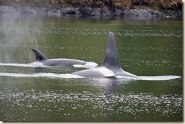
 WEEK 2: Monday, April 22, we headed north, in benign conditions. We noticed smoke shapes over Texada Island. A heart, question mark, other things, then a ring. We wondered if this was a proposal! The mountain ranges have plenty of snow and they were all out. Both on mainland and also on Vancouver Island. Two things we have noticed heading north, lots of gear, prawn and also crab and lots of Buffleheads and Barrow Goldeneyes (both diving ducks that winter over in WA and BC.). We went into Squirrel Cove on Cortez Island, to spend a day at anchor while waiting for our date with Seymour Narrows. Lots of birdlife, including Common loons, Common mergansers, Surf Scoters and a pesky eagle who is scrounging around for some tasty ducklings or some such. On Tuesday it was lovely weather, though the long range forecast was for something to come in on Saturday. We kayaked to shore and hiked to the inlet 1 ¼ miles across the island through beautiful forest with outstanding moss. There were lots of large tree trunks to go up and over, huge Doug Fir and cedar. After lunch back on the boat and near high tide we kayaked to the entrance to a lagoon, best done at high tide, and easy in. Was very nice though it seems we startled several birds. It was 66 degrees and certainly flybridge weather. Wed. morning we pulled anchor and went to Gorge Harbor, which is on the same Island, has a narrow but scenic entrance and is the location of fish farms, lots of second homes and the Gorge Harbor Marina Resort. We anchored but took dinghy in hoping to dine at their well regarded restaurant. Not open this early in the season except weekends. There seems to be a theme, we are very early, and we don’t see other pleasure craft. Thursday we pulled anchor and headed to Campbell River to do shopping for freshies, laundry, wash salt off the boat and make ready to transit the Seymour Narrows bright and early Friday. We departed the dock in the dark at 0430 and were 3 minutes early for the slack at Seymour Narrows, perfect timing. Seymour was no problem, but later, in Race Passage, with the increasing ebb current we got to 12 knots speed, and had to deal with a lot of swirly water. Also, lots of logs. We made it out of Johnstone Straight into our anchorage just as the waters were starting to get choppy. High winds were forecast for Friday afternoon and Saturday, so we planned to be in Port Harvey for a couple of days. It was windy in Port Harvey, and we decided to leave next morning and take Havana Channel inland, timing Chatham Narrows, and on to Waddington Bay in the Broughton Islands. No other boats seen, just logs. We finished the week on Sunday motoring to Claydon Bay, and saw Orca and a HUGE convention of Grebes, hundreds of them floating in a giant patch on the water. At first we thought a large seaweed patch, but no, it was a Grebe patch!
 WEEK 3: On Monday, 4/29, we decided to stick our nose out and try to get to Allison Bay, which is only 16 miles from Cape Caution. The forecast for Tuesday was favorable to Cape Caution. But as we headed out, yet were still in the protected waters of Wells Passage we started to encounter head seas indicative of rather rough water in Queen Charlotte Straight / start of Queen Charlotte Sound. So we turned around and went to Carriden Bay and anchored to wait until Tuesday morning. We couldn’t get the weather on the VHF radio in the anchorage, which would have given us the real time buoy reports and so headed out early Tuesday, and started monitoring the buoy and lighthouse reports. The deck was icy, and we were underway at 6 a.m. We dropped our poles and headed into it, 3 ft head seas, not too much on the beam, the conditions did not worsen and we made it around and into protected waters and anchored at Kwakume Inlet. The conditions for the rest of the week were forecast to be worse, and we later confirmed this via weather reports, so we did hit the weather and sea condition window just right. Being in inside waters we continued Wednesday to Discovery Cove, a new anchorage for us, pleasant enough, still not seeing hardly any vessel traffic, we saw more Orca and also a humpback, all heading north in the same protected waters as we were in. Based on the weather forecast we downloaded via sat phone, we took a storm day in Discovery Cove on Thursday, inside we were OK, some winds in the teens but not in the 20-30s. And on Friday we headed north and did a brief section of outside waters, Milbanke Sound, which was quite OK, and the lighthouse reports (Ivory Island and also McInnes Island) indicated we would find Milbanke OK as we did. Then to Khutze Inlet on the east side of Grenville Channel, an anchorage where you set your anchor on a bar with deeper sections on either side. We did so and pulled the anchor chain to the inland deeper water and this strategy worked well, when the current changed to ebb, i.e. flowing out of the inlet going to low tide, the chain draped down from the bar kept us in a tight area. It was a very pleasant evening, and we sat on the flybridge and watched a group of Steller Sea Lions moving around the anchorage, I assume they were feeding. On Saturday we went to Kumelon, the last inlet on Grenville, and last good anchorage before Chatham Sound, where the Skeena River outlet combined with opposing strong winds can make for some distasteful sea conditions. We passed the Nat Geo Sea Lion small cruise ship, who was outside Baker Inlet and we came to realize they were holding there while small tenders were taking passengers into this inlet, just 6 miles south of Kumelon. We read up on this inlet and later after we anchored and downloaded the weather report decided on Sunday to go back to spend a couple of days in Baker Inlet while waiting for the weather and conditions to improve for crossing Dixon Entrance to SE Alaska.
 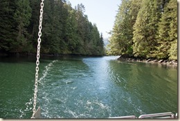 Baker Inlet has a very narrow entrance to the inlet, with a blind corner that you must time to transit it at slack waters, which we did. Once in we were enchanted with the beauty of Baker Inlet. As we have found in all our anchorages, we were the only vessel. The mountains surrounding the anchorage are stunning, and a huge black bear did some beach grazing on grasses to entertain us.
WEEK 4: On Monday, May 5, we stayed put in Baker Inlet, as planned, based on weather forecast and were joined by two other pleasure craft traveling together, including m/v Wildelife, whom we met while cruising in 2007. We also, with a wind shift, decided we were too close to the shallow water and so we pulled anchor and moved into some deeper water, about 100 yards  from original spot. Next morning, we headed out, to catch the morning 6 a.m. slack water to depart the Watts Narrows entrance into the inlet. The conditions became a little rough in Chatham Sound but still OK and we made it to Dundas Island, in position for Dixon Entrance and the favorable forecast for the next day. On Wednesday, May 8 we crossed Dixon Entrance and were tied up in Ketchikan at 12:49 p.m., with no drama in docking. (Ketchikan can be windy!). We had a list of errands to do, laundry, including all the rugs, as the cats had thrown up on all of them by the time we got to Ketchikan! We also did grocery and beverage shopping, obtained fishing licenses, checked email, paying bills, etc, etc. We did really well and were ready to leave Friday morning so we could passage the unavoidable 20 miles of Clarence Straight when conditions were good (but forecast to worsen the next day). We headed for Santa Anna Inlet, which is actually on the mainland, thinking we would try some crabbing and prawning. There were a lot of Dall Porpoises who played on our bow wake along the way, always wonderful. I mean a lot, and a set of three accompanied us into Santa Anna. We set our pots and the next morning discovered nothing, except starfish. So we decided to move to an area we previously had some luck in, Thoms Place on Etolin Island. Along the way, we saw a humpback whale and our autopilot failed! That was disturbing to say the least. As it happens, in contrast to most pleasure craft, we have a backup autopilot and so we were able to switch to this. Thom’s place was lovely as we remembered it, we set out crab pots and did some further investigation of the failed autopilot, AP-1. A 20 amp fuse had blown and provided an error message. So we decided to cut anchorages short and stop in Wrangell on the way to Petersburg. But not before getting several crab in Thom’s Place.


